
The Lost 30th Street Trolley Bridge Over San Diego’s Switzer Canyon
The Lost 30th Street Trolley Bridge Over San Diego’s Switzer Canyon
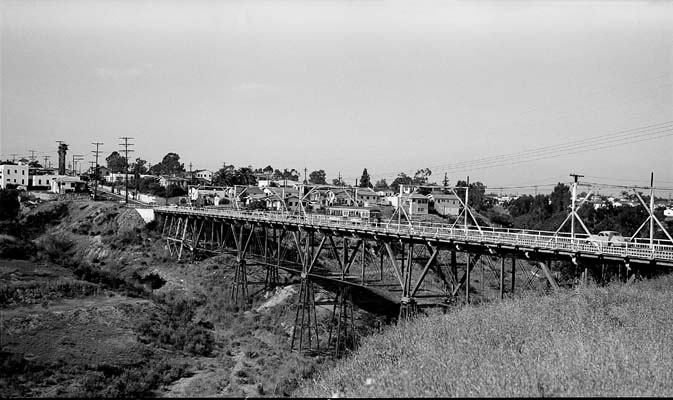
A familiar drive between North Park and South Park gets a lot more interesting when you see what used to hold up the road.
An old photograph of the 30th Street crossing shows a long trestle stretching over Switzer Canyon. Underneath the roadway is an exposed framework of supports. Along the top are streetcar tracks and narrow sidewalks.
It takes a second to connect that image with the crossing people use today.
And once you do, the obvious question is: What happened to the bridge?
Where was the 30th Street trolley bridge?
The original bridge crossed Switzer Canyon along 30th Street between Laurel and Olive, near Burlingame and the connection between North Park and South Park.
That location is what makes this story so good. You can put an old photograph beside a current view and recognize the same route, even though the structure beneath it changed dramatically.
For me, that is one of the best reasons to learn neighborhood history. It gives an ordinary trip another layer.
A canyon crossing helped connect growing neighborhoods
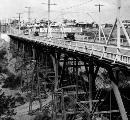
The bridge was completed in 1908. The South Park Historic District record places the streetcar extension into North Park the following year.
That distinction matters: the bridge’s completion and the railway’s expansion were related steps, rather than necessarily one opening-day event.
Streetcars helped connect homes outside downtown with jobs, shopping, and other parts of the city. A canyon presented an obvious obstacle to a continuous route. The trestle helped overcome it.
The neighborhood record also describes commercial activity developing along the trolley corridor, including around 30th and Beech, Grape, and Juniper.
I find that connection fascinating. When you look at a neighborhood’s shops and main streets, transportation history can help explain why activity gathered where it did.
What crossing the old bridge felt like
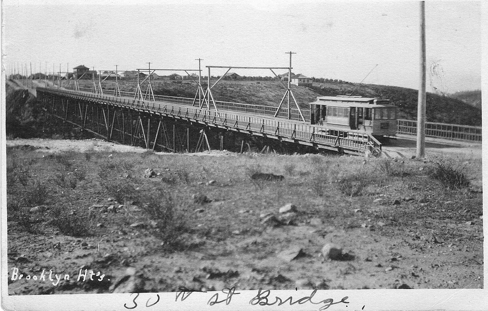
Photographs show the structure. Residents’ memories supply something a photograph cannot.
Genealogist Randy Seaver published a bridge photograph from his grandfather’s collection and described riding across it on his bicycle in the early 1950s. He remembered worrying about catching his tires in the wooden planks or running over the trolley tracks.
That is a very specific way to remember a road.
Burlingame resident Evelyn Roy Kooperman offered another perspective in her childhood recollections. When a bus approached, children would run toward the middle of the bridge and put their chins against the railing to feel the shaking.
Apparently, watching traffic was a little more interactive back then.
These are personal recollections, and that is how they should be understood. They also make the crossing feel real: a place people used, worried about, and turned into part of their childhood.
Why the trestle disappeared
The North Park Historical Society describes a structure that became difficult to maintain as traffic increased and fires and floods caused damage.
The bridge closed in August 1956.
Its replacement took a very different approach. An earthen causeway was built using fill from improvements to Nile Street to the east. The new crossing opened on May 23, 1957.
That changed more than the appearance of the roadway. An open trestle had allowed the canyon to continue beneath its framework. The built-up crossing divided that space, with a drainage tunnel connecting the canyon’s two sides.
The important point is that the current crossing replaced the original bridge. Seeing the location today does not mean you are seeing the old trestle.
A different way to see 30th Street
The next time you cross between Laurel and Olive, picture the historical photograph: the roadway above, the framework underneath, and the canyon extending below.
Then think about someone carefully steering a bicycle over wooden boards. Or a child waiting for a bus so the railing would shake.
Those details make this piece of San Diego history stick with me.
Knowing a neighborhood means learning how it became the place we experience today. Sometimes that starts with a building. Sometimes it starts with a photograph of a bridge that is no longer there.
I love this frickin city.
Matt Thornberg is a San Diego real estate agent and team leader of Thornberg Home Group, always looking for another reason to say, “I love this frickin city.” He helps first-time homebuyers and current homeowners move up, downsize, or relocate with deep local knowledge, straight-shooting advice, and proven marketing and negotiation strategy. Matt specializes in the central San Diego neighborhoods surrounding Balboa Park, including Golden Hill, South Park, North Park, Mission Hills, University Heights, Normal Heights, Hillcrest, and Bankers Hill. Let’s talk about your next move.
Direct Sources and Archival Image Leads
- North Park Historical Society, September 2024 meeting summary, page 3
Detailed construction, closure, replacement, fill-source, and reopening chronology. - City of San Diego historic inventory: South Park Historic District
Railway expansion and neighborhood development context, with historical newspaper references. - Randy Seaver: The 30th Street Bridge in San Diego
Family-collection photograph, structural description, and bicycle recollection. The photograph’s estimated date range is the author’s estimate. - Evelyn Roy Kooperman: Burlingame Memories
Firsthand childhood account, originally presented for Burlingame’s centennial. - San Diego History Center: Balboa Park History, 1908
Archival chronology referencing the November bridge inspection. - San Diego Reader: Switzer Canyon
Canyon context and an archival trestle photograph credited to the San Diego Historical Society. - San Diego Reader: Switzer Canyon Drainage Tunnel
Documentation of the tunnel beneath the replacement causeway. - City of San Diego: FY2026 Capital Improvements Program
Lists Switzer Canyon Bridge Enhancement, project P21006.
Categories
- All Blogs (12)
- bankers hill (1)
- central san diego (1)
- downtown san diego (2)
- golden hill (1)
- hillcrest (1)
- living in san diego (8)
- mission hills (1)
- moving to san diego (2)
- neighborhood guides (1)
- normal heights (1)
- north park (3)
- san diego (9)
- san diego history (6)
- san diego lifestyle (8)
- san diego living (10)
- san diego neighborhoods (4)
- san diego news (7)
- san diego nightlife (1)
- san diego real estate (4)
- san diego restaurants (2)
- south park san diego (4)
- university heights (2)
Recent Posts

GET MORE INFORMATION